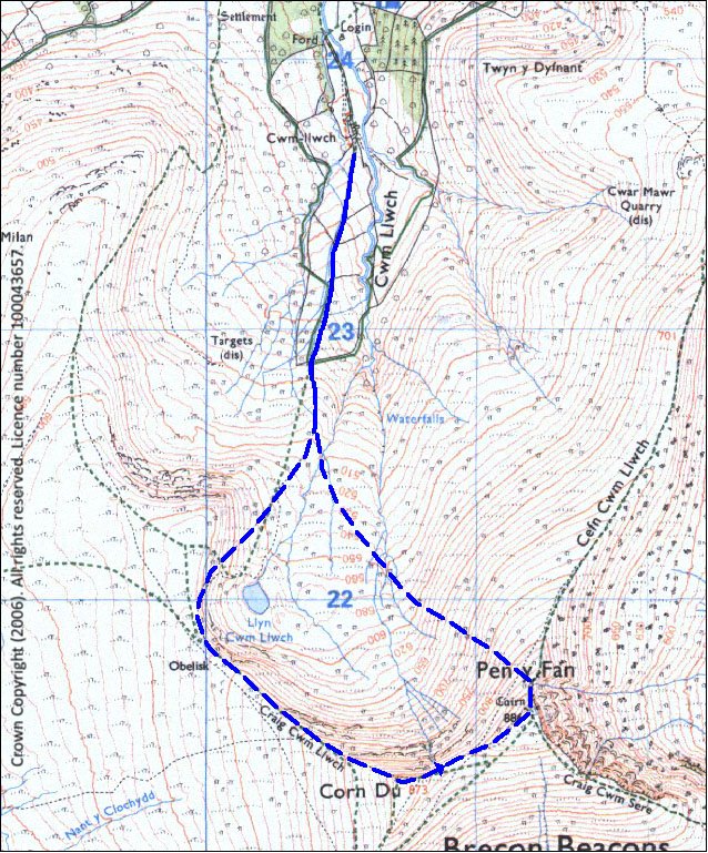
Pen y Fan Race Route Description
The race starts from the bottom of the field just beyond the last farm building (now a school bunkhouse). Please note this is about 10 minutes walk from registration, so give yourself plenty of time.
The first quarter of a mile or so is on an old stoney track, then out onto a grassy slope getting steeper up to a fence and stile. The stile can be a bottleneck, for annoying delay or a welcome breather. After the stile, which takes you onto National Trust land, a walkers’ path keeps to the right-hand side of the valley, climbing steadily and narrowing towards the skyline. The path levels out as you reach the main scarp edge, passing the obelisk erected in memory of Tommy Jones, a small boy who got lost and met his end here.
NB do not take a sudden left at any point from now until after the summit of Pen y Fan – there is a precipitous drop.
Now the steepest part of the climb begins, about half a mile up the man-made path up to the summit of Corn Du. We usually have a photographer at the summit, so no vomiting please. You should go straight across the summit plateau, keeping towards the left side (remember… no sudden left turns, but don’t turn right either unless you want to go to Merthyr). Then a loose rocky descent takes you to a large path across to Pen y Fan, climbing on a man-made path onto the large summit area.
If you keep near the left edge from Corn Du to Pen y Fan, we will be able to see you from the start/finish field with binoculars. Meanwhile keep your own eyes peeled for the rather nice sandstone ripple-bedding, and then give a lovely smile for the marshal(s) and photographers(s) at the summit cairn.
Note in passing that the cairns on Corn Du and Pen y Fan are Bronze Age burial mounds (probably for eminent fell runners of the day).
At the Pen y Fan summit cairn, you may now turn left, in fact you must, while making a mental note that Keith Anderson descended from here to the finish in 7 minutes. Try to leave the loose eroded path as soon as you can, in order to take a straight-line grassy descent. If you get off the path within 10m of the top that’s fine, though it is quite steep - we've had a few refusals here. You can go further on down the path and ridge if you want, but if you go too far before turning left you run the risk of having to cross the valley where the stream turns into a ravine.
The descent is steep and a bit tussocky, with enough sharp stones to make you think twice about rolling down. Head straight down the slope, until it starts to level out, when you should bear a bit right across the rougher ground. If you head for the right-hand shoulder of the hills on the opposite side of the valley (NW), you won’t go too far wrong. This area can be marshy, with a couple of small gullies/streams to cross, but you should find yourself re-joining the outward route not far above the fence and stile. From there it’s about another half mile to the finish – many runners stay in the field to the right of the line of trees, instead of following the outward track.
NOTE – please take extreme care on the summits of Corn Du and Pen y Fan, especially in poor visibility, as there are dangerous drops on the northern side of Corn Du (on your left on the race) and on the eastern side of Pen y Fan (ahead, if you don't turn left at the summit cairn). Take care when descending off the summit plateaus.

Bad Weather Route
In the event of extreme bad weather, we will use an alternative route where runners simply have to run around the top of Llyn Cwm Llwch (the small tarn below the ascent route) and return to the start. This is about 2 miles.